feature (id #5):
Benthic Classes
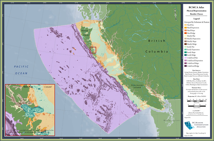
| category | physical |
| description | Classification of the sea floor based on landscape features, substrate, and depth. |
| atlas page | view PDF (4.3 MB) (Find in our 2010 printed atlas on page 7.) |
| metadata | view online |
| feature GIS data | download ZIP of shapefiles (25.4 MB) |
| Marxan metadata | view online |
| Marxan-ready data | download ZIP of shapefiles (40.4 MB) |
See our Glossary to learn about these terms (metadata, feature GIS data, Marxan-ready data, etc)
4 comments about this feature
comment on this feature
for data layer: Benthic Classes
custodian — Parks Canada: Greg MacMillan
how to access the restricted data
This feature was created from 1 raw data layer. Each data layer has a custodian and different restrictions as to which types of data BCMCA may distribute on this website. The unrestricted feature and Marxan-ready data are available to download at the map & data tab. To gain access to the restricted data, please go through the following process:
- Determine whether you are interested in the feature data or Marxan-ready data. (See the Glossary for descriptions on these data types.)
- Using the info below, make a list of the custodians you will need to contact for permission to use the data. Please note that many of the features use similar data layers and require permission from the same custodians. Also note that BCMCA does not supply the contact information for the custodians, but they can be found through web searches. Then contact each of the custodians directly, indicating:
- which features you are requesting permission to have data for
- whether you are requesting the feature data or Marxan-ready data
- When all of the required permissions have been received for a feature or set of features, please forward the email confirmations to the BCMCA data custodian at info@bcmca.ca to obtain the data.
An index of all the data custodians for ALL features is available here.
Hello,
We’re trying to use this layer to discern areas of preferable rockfish habitat, however are not clear on what the polygon values (#’s) correlate to the three categories of physical behtic classes (landscape features, depth ranges and substrate types). Without this information, it’s not clear to us which characteristics are found in each polygon.
Thanks
Jenna
Hi Jenna,
In the ‘supplemental information’ field of the metadata there is a table showing how the values in the ‘habClass’ field correlate to the depth class, substrate, and benthic position index information. I find the table easier to work with if you view the XML version through ArcCatalog because the formatting is somewhat lost in the HTML version. The values use the following code:
depth class (1000s) | substrate (10s) | benthic position index (1s)
Depth
< -200m 4000 -200 - -50m 3000 -50 - -20m 2000 -20 - 0m 1000 Substrate M = Mud 10 S = Sand 20 H = Hard 30 U = Unknown 90 BPI 1 Ridge 2 Depression 3 Flat 4 Slope Hopefully that helps! Please let me know if you have any other questions. Cheers, Carrie
Hi
Benthic Classes ZIP file will download but not open. Zipfile seems to be incompelte.
Thanks
Hi Dave, Thanks for catching this! The file has been re-zipped and re-uploaded.